Cyclone Akvan forms in Bay of Bengal, heads for India's Andhra coast
Cyclone Akvan formed over the Bay of Bengal on the evening of 16 November 2026 and is forecast to cross India's Andhra Pradesh coast between Nellore and Tuni by noon on 20 November as a very severe cyclonic storm, with winds of 120–130 km/h gusting to 145 km/h, according to the India Meteorological Department.
Update, 16 November 2026, evening: The India Meteorological Department said in its 5:30pm (India time) bulletin that the deep depression had strengthened into Cyclonic Storm Akvan. The forecast is broadly unchanged: a severe cyclonic storm by Tuesday evening, a very severe cyclonic storm by Thursday morning and landfall between Nellore and Tuni around noon on Friday, 20 November. The latest details are in the section "What changed on Monday evening?" below. The rest of this article was first published on Monday morning, before the storm was named.
A weather system in the Bay of Bengal is expected to become Cyclone Akvan on Monday evening, 16 November 2026, and to hit India's Andhra Pradesh coast later this week as a very severe cyclonic storm. In its Monday morning bulletin, the India Meteorological Department (IMD) said the system is very likely to cross the Andhra Pradesh and Yanam coasts between Nellore and Tuni by noon on Friday, 20 November, with maximum sustained winds of 120–130 km/h gusting to 145 km/h.
At 8:30am India time on Monday the system was a deep depression centred about 700 km east-southeast of Chennai and 800 km south-southeast of Visakhapatnam, moving slowly north-northwest at about 6 km/h. Odisha has ordered early evacuations of vulnerable areas in its southern districts, Andhra Pradesh has told fishermen to stay ashore until 20 November, and Tamil Nadu, Odisha and West Bengal have all been warned of heavy rain. It would be the third cyclone to form in the Bay of Bengal in about three weeks.
What changed on Monday evening?
IMD said the deep depression moved north-northwest at about 10 km/h over the six hours to Monday evening and strengthened into Cyclonic Storm Akvan. At 5:30pm India time it was centred over the south and west-central Bay of Bengal, about 610 km east of Chennai, 630 km north-east of Trincomalee in Sri Lanka, 660 km south-east of Machilipatnam, 670 km south-south-east of Visakhapatnam and 790 km south of Gopalpur in Odisha.
The forecast track and strength are largely the same as on Monday morning. IMD expects Akvan to become a severe cyclonic storm over the west-central Bay of Bengal around Tuesday evening, 17 November, and a very severe cyclonic storm around Thursday morning, 19 November. It then expects the storm to cross the Andhra Pradesh and Yanam coasts between Nellore and Tuni around noon on 20 November, with sustained winds of 120–130 km/h gusting to 145 km/h. The Hindu reported that current models point towards the Machilipatnam area, but that IMD still describes the landfall point as anywhere in that stretch.
In Andhra Pradesh, Konaseema, Kakinada, East Godavari, West Godavari, Krishna, NTR and Guntur districts have been put on alert for very heavy to extremely heavy rain on 19 and 20 November, according to The Hindu. Rain is expected to start on 18 November. Chief Minister N. Chandrababu Naidu reviewed preparations on Monday, told officials to take precautions and asked them to steer floodwater into reservoirs, because the state still has an overall rainfall deficit of 27.2% this season. The state fisheries department has issued an alert for all 12 coastal districts. By 10am on Monday, 30,635 of the state's 30,808 fishing boats had returned to shore, and efforts were under way to bring back the other 173.
Elsewhere, IMD forecasts heavy rain with thunderstorms and gusts of 40–50 km/h in Chennai, Tiruvallur and Chengalpattu from 17 November, spreading to more Tamil Nadu districts and Puducherry from 18 November, the Hindustan Times reported. Odisha says it is prepared, and some districts have asked for more national and state disaster response teams.
What is the latest forecast?
IMD, which is also the World Meteorological Organization's regional specialised centre for cyclones in the north Indian Ocean, expects the deep depression to strengthen into a cyclonic storm over the south and west-central Bay of Bengal on Monday evening, and into a severe cyclonic storm by the evening of Tuesday, 17 November. It is then forecast to strengthen further while turning west-northwest towards the coast.
The centre's tropical weather outlook, issued at 0330 UTC on 16 November, sets out the expected growth step by step. It forecasts winds of 60–70 km/h, gusting to 80 km/h, when the system becomes a cyclonic storm at 1200 UTC on 16 November (5:30pm India time); 90–100 km/h by 1200 UTC on 17 November, when it becomes a severe cyclonic storm; and 115–125 km/h gusting to 140 km/h by 1200 UTC on 19 November, when it is forecast to be a very severe cyclonic storm. Satellite analysis at that point put the system's central pressure at about 1003 hPa.
Later on Monday morning IMD narrowed the landfall window to the stretch between Nellore and Tuni by noon on 20 November. The Hindu calculated that this covers about 500 km of coast, nearly half of Andhra Pradesh's 1,053 km shoreline, with Machilipatnam roughly in the middle. Earlier forecasts had pointed further north, towards north coastal Andhra Pradesh and south Odisha, and IMD has warned that the models disagree on the storm's later track, strength and timing. The landfall point could still move.
Why is it called Akvan?
Storms in the north Indian Ocean are named in turn from a list agreed by 13 countries in the WMO/ESCAP Panel on Tropical Cyclones. A system gets the next name only once it reaches cyclonic-storm strength. IMD gave the name Akvan when it declared on Monday evening, 16 November, that the depression had become a cyclonic storm.
Akvan is Iran's contribution to the list. According to the WMO table, it comes after Arnab (from Bangladesh) and Murasu (from India), the names of the two previous storms, and will be followed by Kaani (from the Maldives). The name of a storm has no connection to the country it threatens. Indian media have noted that Akvan is also the name of a demon in the Persian epic the Shahnameh, but the official list gives no meaning for it.
Which areas are on alert?
Andhra Pradesh. IMD has issued a pre-cyclone watch for the Andhra Pradesh and adjoining south Odisha coasts. According to the IMD district warnings reported by the Hindustan Times, red alerts for extremely heavy rain are in place for districts including Bapatla, Krishna, West Godavari, East Godavari, Kakinada and Eluru on Thursday, 19 November, and for West Godavari, East Godavari, Eluru and Konaseema on Friday. IMD said squally winds of 50–60 km/h could start along the coast from Monday and gradually build to gale force, with sea conditions getting much worse after 17 November. District officials have advised suspending offshore operations.
Odisha. The state government has put all 30 districts on alert, set up 24-hour control rooms and placed national and state disaster response teams and fire services on standby, PTI reported. On Monday it ordered southern districts to begin early evacuations of hilly and low-lying areas. Ganjam's district collector said people would be moved "well before the rains". Farmers have been told to harvest crops before the rain expected on 18 and 19 November, and fishermen were told to return to shore by 16 November. Heavy to very heavy rain is forecast at isolated places in Odisha from 19 to 21 November.
Tamil Nadu and West Bengal. IMD expects heavy to very heavy rain at isolated places in Tamil Nadu on 18 and 19 November, with orange alerts for Chennai, Tiruvallur and Chengalpattu on those days. In West Bengal, heavy rain is possible in the coastal districts of South 24 Parganas and Purba Medinipur from 19 to 21 November.
Why does a third storm in three weeks matter?
The same coast is still recovering from two recent storms. Very Severe Cyclonic Storm Arnab made landfall near Narsapur in West Godavari district in the early hours of 28 October, with winds of 125–135 km/h. The Hindu reported at the time that five people died in rain-related incidents in Andhra Pradesh, more than 1,000 trees were uprooted and crops on about 80,500 hectares were affected. Arnab's rain also caused floods and damage in southern Odisha. Severe Cyclonic Storm Murasu followed earlier this month, making landfall near Ongole in south coastal Andhra Pradesh.
Repeated storms mean repeated losses for people whose income depends on the sea and the fields. At Visakhapatnam fishing harbour, a fishermen's leader told The Hindu that the recurring disruption had "crippled livelihoods" during a season when fish sales are already slow. A fisheries official said Arnab caused about ₹307 lakh (₹3.07 crore) of damage to fisheries in Visakhapatnam district alone, and that compensation was still awaiting a decision. Ground that is already soaked and rivers that are already high can also make fresh rain more dangerous.
What do the storm categories mean?
IMD grades storms by their maximum sustained surface wind, the average wind speed rather than short gusts. A depression strengthens into a deep depression, then a cyclonic storm, a severe cyclonic storm and a very severe cyclonic storm. Very severe storms can damage weak houses, bring down power lines and trees, flatten crops and push seawater inland. The forecast landfall strength of 120–130 km/h is similar to Arnab's landfall winds in October.
What happens next?
Forecasts will keep changing as the system develops, so the exact landfall point and timing are not yet settled. IMD issues bulletins several times a day. Akvan reached cyclonic-storm strength on Monday evening as forecast. The key points to watch now are whether it becomes a severe cyclonic storm by Tuesday evening as forecast, and whether the landfall window between Nellore and Tuni gets narrower. People in the affected states should follow IMD and their state disaster management authorities, including Andhra Pradesh's APSDMA, for warnings and evacuation orders.
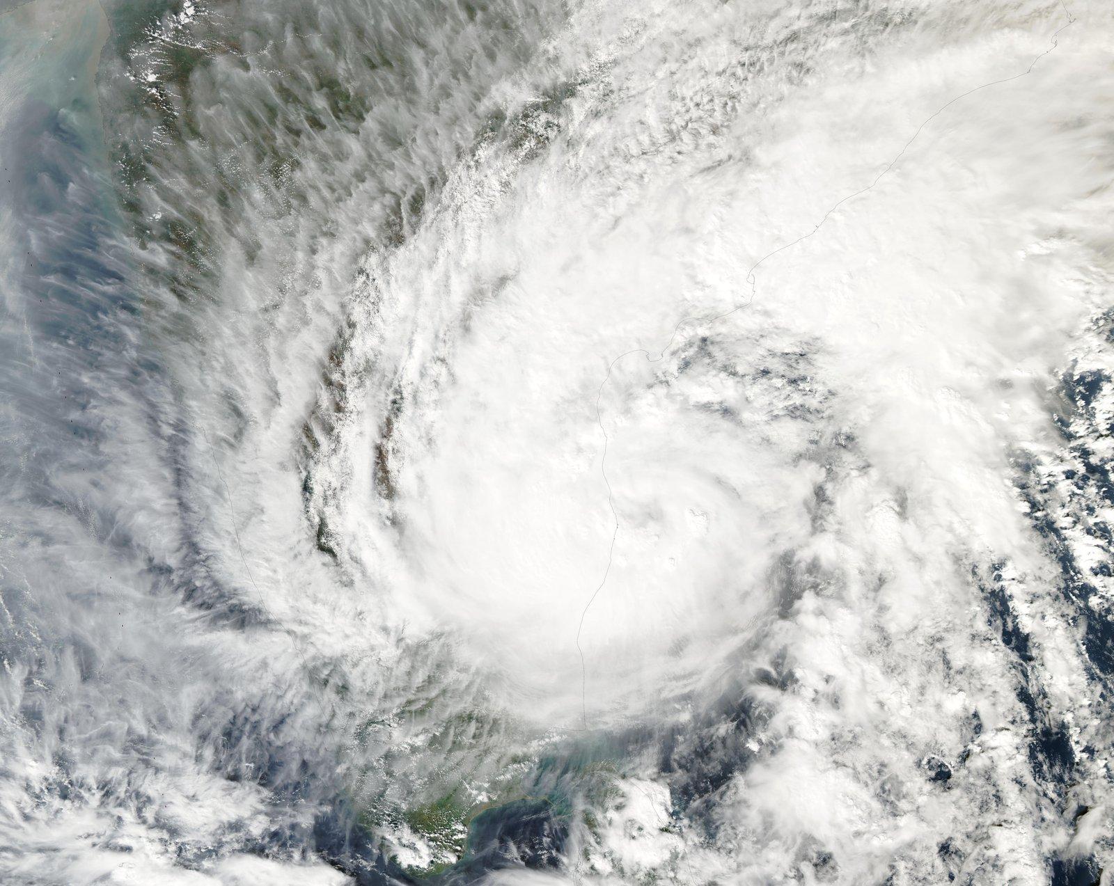
Image: Image: MODIS Land Rapid Response Team, NASA GSFC, public domain, via Wikimedia Commons (https://commons.wikimedia.org/wiki/File:Tropical_Cyclone_Michaung_(MODIS).jpg) — file image of Cyclone Michaung approaching India's coast in December 2023; it does not show the 2026 system; resized
About this article: prepared by The Daily Context editorial desk using automated, source-based reporting from the publications linked below. No reporter was on the ground.
Sources
- The Hindu, "Cyclonic Storm Akvan forms over the Bay; CM tells officials to take precautionary steps" (16 November 2026), quoting IMD's 5:30pm IST bulletin: https://www.thehindu.com/news/national/andhra-pradesh/cyclonic-storm-akvan-forms-over-the-bay-cm-tells-officials-to-take-precautionary-steps/article71708721.ece
- India Meteorological Department (RSMC New Delhi), Tropical Weather Outlook based on 0000 UTC of 16 November 2026: https://mausam.imd.gov.in/backend/assets/cyclone_pdf/Tropical_Weather_Outlook_based_on_0000_UTC_of_16_11_2026_compressed.pdf
- The Hindu, "Cyclone Akvan to cross Andhra coast between Nellore and Tuni by November 20 noon, says IMD" (16 November 2026), quoting IMD's 8:30am IST bulletin: https://www.thehindu.com/news/national/andhra-pradesh/cyclone-akvan-to-cross-andhra-coast-between-nellore-and-tuni-by-november-20-noon-says-imd/article71706785.ece
- Hindustan Times, Bay of Bengal system live updates (16 November 2026): https://www.hindustantimes.com/india-news/severe-cyclonic-storm-akvan-live-updates-imd-bay-of-bengal-deep-depression-odisha-andhra-coast-rain-alert-landfall-101794791541264.html
- The New Indian Express, "TN, Andhra & Odisha on alert as 'Akvan' to become severe cyclone by Tuesday" (16 November 2026): https://www.newindianexpress.com/india/2026/Nov/16/tn-andhra-odisha-on-alert-as-akvan-to-become-severe-cyclone-by-tuesday
- Moneycontrol / PTI, "Cyclone Akvan: Odisha alerts all 30 districts as storm brews over Bay of Bengal" (16 November 2026): https://www.moneycontrol.com/city/cyclone-akvan-odisha-alerts-all-30-districts-as-storm-brews-over-bay-of-bengal-article-14080947.html
- World Meteorological Organization, Northern Indian Ocean tropical cyclone names: https://wmo.int/content/tropical-cyclone-naming/northern-indian-ocean-names-arabian-sea-and-bay-of-bengal
- NDTV Profit, "Cyclone Akvan: Origin of the name and what you need to know": https://www.ndtvprofit.com/india/cyclone-akvan-origin-of-the-name-and-what-you-need-to-know-12324050
- The Hindu, "5 dead as Cyclone Arnab batters north Andhra with heavy rain" (28 October 2026): https://www.thehindu.com/news/national/andhra-pradesh/5-dead-as-cyclone-arnab-batters-north-andhra-with-heavy-rain/article71636779.ece
Kabeer Ahmad
Kabeer Ahmad is the founder and editor of The Daily Context. He oversees the site's source-based coverage of world affairs, technology, business, entertainment, lifestyle and sports, and is responsible for its editorial standards, sourcing and corrections.